Writer’s Note: I’d like to dedicate this blog to my father who recently passed away. He taught me the love of travel, to be curious, and to seek adventure, all with a healthy dose of humor. Will forever miss him.
Back in October 2016, I rode the Katy Trail in segments, either hiring a shuttle to drive us to a trailhead and then ride back to the hotel or sometimes choosing to do out-and-backs. After that trip, I pledge to return and bikepack the trail.
Fast forward nearly a decade, and a member of my local bike club was organizing that exact trip. The itinerary consisted of four days of credit card bikepacking (staying in hotels) and riding 231 miles from Windsor to St. Charles, Missouri, with 2,481 feet of elevation gain. Since the Katy Trail is a Rails to Trails, we’re talking gentle grades because of a locomotive’s limitations. Still, that 2% grade can become a bit of a grind over several miles, especially with 40 pounds of gear. But hey, that’s all part of the adventure, right?
Trail History
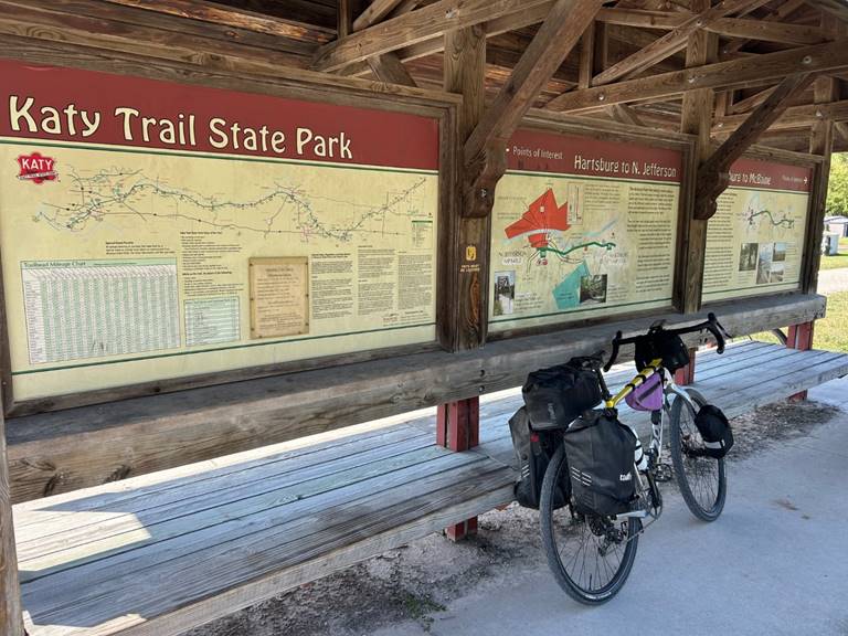
The trail was built on the former corridor of the Missouri-Kansas-Texas Railroad (MKT, or Katy) and is 240 miles long, running between Clinton, Missouri (in the west) and Machens, near St. Louis, with 26 trailheads and four fully restored railroad depots. Much of the trail runs along the Missouri River on one side and high bluffs on the other. Most of the trailheads have bathrooms and water, with some providing a pump and bike tools.
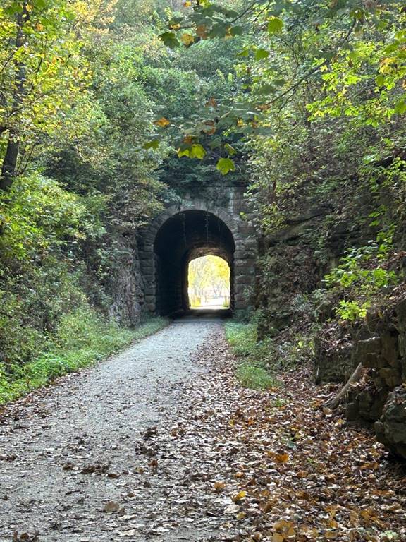
You’ll continually be reminded of the trail’s history as you see old telegraph poles and other remnants of the railroad’s past. The trail passes over numerous types of steel bridges, including pony truss, through truss, and trestle. Along the trail, you’ll ride through small rural towns that once thrived along the railroad corridor. These communities make great places to stop and explore.
Lewis and Clark are also part of the trail’s history. Napoleon offered the Louisiana Territory for sale in 1803, and President Thomas Jefferson directed Lewis and Clark to map and explore the lands west of St. Louis in search of a water route to the Pacific.
Daniel Boone is also an iconic figure who played a role in the history along the trail.
The Packing Puzzle
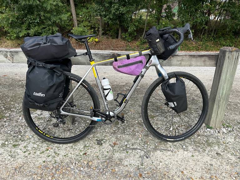
My August bikepacking adventure on the Elroy-Sparta trail was just a warm-up for this longer Katy Trail trip – four days carrying everything on the bike. About six weeks out, Chicago temperatures were starting to get chilly. I worried that warmer clothing would be necessary, which would require more storage. For Elroy-Sparta, I used Tailfin 16L panniers, as the temperature was 90 degrees during the day.
The Tailfin team upgraded me to larger 22L panniers, giving me extra room for layers. However, Mother Nature caught a second wind and decided to bring back 90-degree heat. Like any obsessed cyclist, I sat and watched the weather forecast for St Charles starting two weeks out, hoping for warm, dry conditions. And that’s precisely what we got – 90 degrees each day, light winds, and not a drop of rain in sight.
As I laid out my gear in my guest bedroom, Coco Chanel’s advice to “take one thing off before you leave the house” came to mind. Well, the famous designer was referring to accessories, but I took it as a cue to pare down my packing list. Our group chat was filled with banter about what everyone was bringing – from minimalist single rear bags to elaborate setups with rear panniers, handlebar bags, top tube bags, and frame bags. It was a fun exercise in comparing our different approaches to packing for the trip.
Check out my gear list at the end of this article.
The Gathering of the Troops
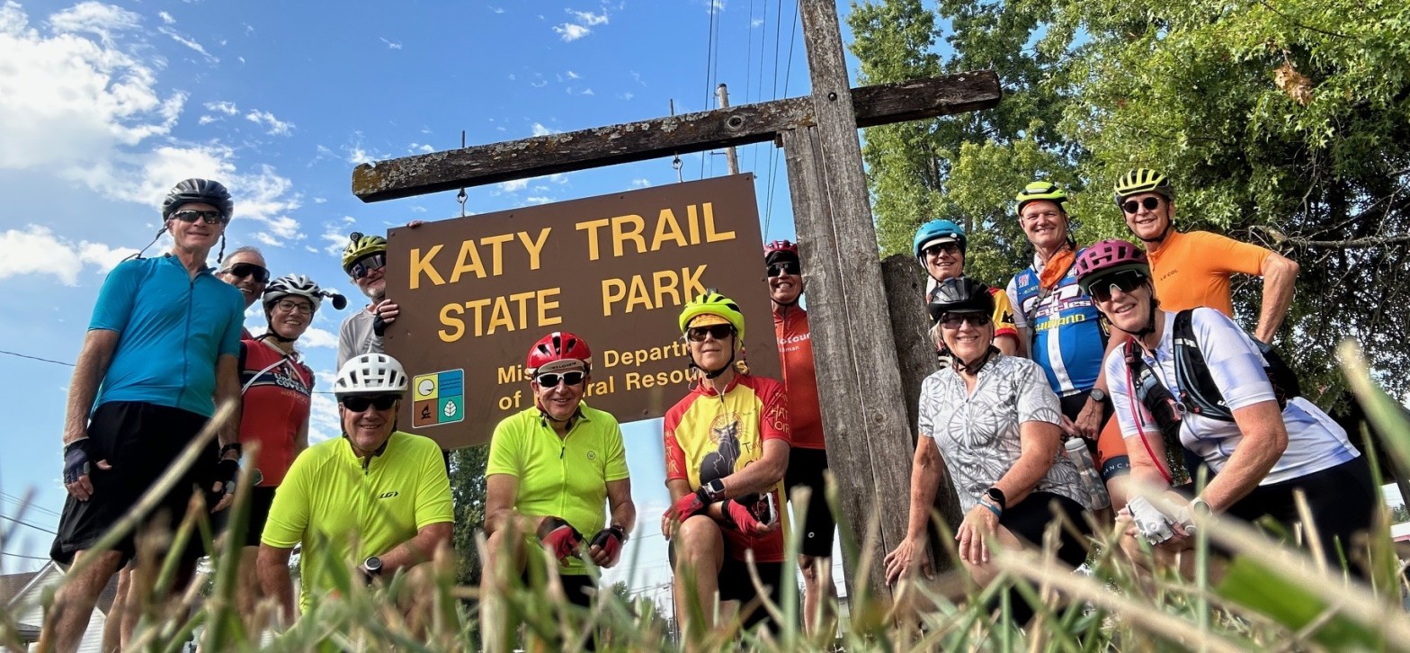
On September 30th, 13 of us made our way from the Chicagoland area to the Comfort Inn in St Charles, MO. It was a relatively easy 4.5-hour drive for me. We met in the hotel lobby that evening and walked along cobblestone sidewalks to the South Main Historic District of St Charles for dinner at 1818 Bistro. The building was constructed in 1818, originally the Eckerts Tavern, which served travelers, settlers, and pioneers as they traversed the country during the Great Migration. Additionally, the building served as the site for the crafting of the Santa Fe Trail documents. It was poetic that we started our journey at this historic building, as there was plenty of history to learn over the next four days along the trail.
As we wrapped up our evening and headed back to the hotel, we covered the morning shuttle logistics and got a preview of the next day’s ride. The conversation took an interesting turn when one of our riders revealed her passion for turtles, even sharing a photo showcasing the 21 species found in Missouri. I chimed in, sharing that I had seen a bald eagle on my last trip and hoped to catch a glimpse of one again.
Day 1: Wednesday, October 1st – Windsor to Booneville (58 miles, 1024 ft of elevation)
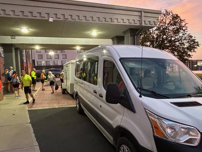
We gathered early, catching a stunning pink sunrise as we waited for Katy Bike Rental to shuttle us and our gear to the Windsor trailhead, a three-hour drive west. The serene morning atmosphere was suddenly disrupted when a couple realized they’d left their bike racks at home. Thankfully, they acted quickly, making a swift 6 a.m. trip to Walmart, where they were relieved to find two racks in stock.
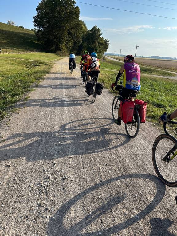
Once at the Windsor trailhead, everyone started getting ready. It was interesting to see the variety of bike and gear combinations. Three of us had Tailfin racks, but different models. It was also amazing to see the volume of gear, ranging from minimalistic to the kitchen sink. I was riding my Salsa Cutthroat with the same 45c tubeless tires used for Unbound Gravel. Note that you don’t need such a wide tire on the Katy Trail since it is mostly well-maintained crushed stone and gravel.
By 11 a.m., we set off eastward, pedaling 58 miles towards Booneville. As we rode, the group naturally broke into smaller packs based on our individual paces. The trail unfolded through a mix of wooded forests and open farm fields. In the forested areas, a single strand of spider webs hung from the branches over the trail. A single small leaf was magically suspended from the ends of each web, almost like raindrops. It was pretty cool to see, except when the web was long enough to hit you in the face as you rode under it.
Soon, we realized two hazards were sure to take a rider down over the next four days. The first was the abundance of walnuts scattered across the trail – hit one just right and it could easily take out a wheel. The second hazard presented itself in the form of the gates installed by the DNR to prevent motorized vehicles from accessing the trail. These brown gates were extremely difficult to see in the shade, sometimes causing you to make last-second maneuvers to avoid them. The gate configurations seemed random – sometimes they’d be open on the left, other times on the right, or to keep you on your toes, closed with just enough of an opening to pedal through the middle. Yep, a crap shoot. What’s puzzling is the lack of additional yellow reflective material to improve visibility.

Riders trickled into the lunch stop, which was at a supermarket a mile from the Sedalia trailhead. Sadly, our first and only rider arrived bruised and bloody from a gate incident. Looking down for just a moment, and wham, she clipped the gate and went down. Riding with panniers, gravity comes into play, and the weight of the bags can cause you to topple over. It’s like the Artie Johnson character on Laugh In who slowly falls over on his tricycle.
Refueled, we headed back to the trail using a “shortcut” along a busy road. Unfortunately, when we arrived, the trail was located on a bridge going over the road. The only way to access it was climbing up a 20-foot embankment on a narrow, rooted, gravely path behind a strip mall. Not wanting to backtrack on the busy road, I headed up the embankment in bike shoes with my 40+ pounds of gear in tow. I had to use the bike’s brakes to prevent it from sliding down the embankment, and it gave me leverage to pull myself up. Not saying it was the smartest thing I’ve ever done, but several of the guys followed right behind me. Wish I had a video to document the insanity.
Once back on the trail, we pedaled the miles away until the town of Booneville, and our first sight of the Missouri River. It was a long day, and I was eager to check into the hotel, which was located right on the trail. That evening, the group had dinner at Maggie’s, and we swapped stories from the day’s ride. Several folks saw box turtles sunning themselves on the trail, while most of us complained about the walnuts. Two people riding with tubes got flats.
After dinner, we grabbed ice cream from a cute place next door and walked through town on the way back to the hotel. A few blocks into our walk, a group of teenagers stopped us. They were on a scavenger hunt, and one of the items on the list was to get a random stranger to reenact the Village People’s YMCA routine. Well, they asked the right group, and there we are doing the hand motions and dancing. I can’t help but think it was really a TikTok challenge.
Day 2: Thursday, October 2nd – Booneville to Jefferson City (52.5 miles, 394 ft of elevation)
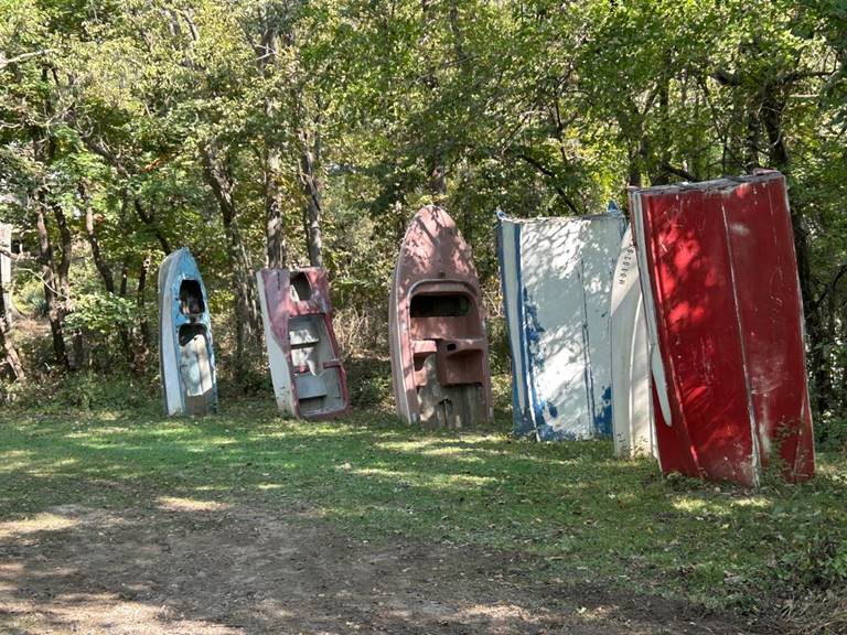
Another early morning, with a quick breakfast at Main Street Diner. With our bellies full, we pedaled across the river heading northeast on the trail. Along the way, we saw two species of turtles, woodchucks, kamikaze red squirrels, but fewer walnuts and no eagles. Oh yes, there was this Boat Henge oddity.
Lunch today was at a shack along the river, where I had a stale turkey sandwich. The place also offered catfishing, which no one took them up on.
When we arrived at the Jefferson City trailhead, it became like a scene from The Amazing Race. Your team had to figure out how to navigate from the trailhead to the hotel without getting on the expressway. Luckily, we found a local couple just setting off to ride, and they clued us in. They said, “Go down this hidden trail spur, right, left, right, left, until you get to a square shape pedestrian/bike ramp that will get you safely across the river without getting on the expressway.
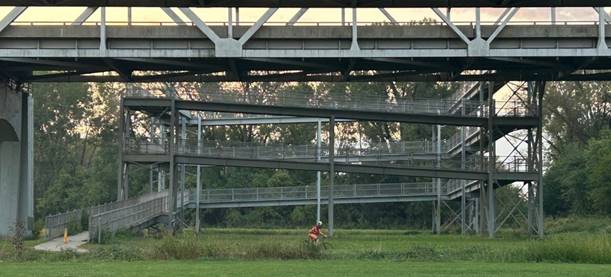
The bike/ped ramp was an odd one. Most ramps go round and round in circles to get you up to the bridge level. This one was square. There was concern that we’d be pushing our loaded bikes up a steep incline, but once on the ramp, it was a gradual ascent and easy to pedal – don’t look down!
Our group of four was the first to check into the hotel, and we rushed to shower, hoping to catch the last Missouri State Capitol tour. We saw a few more riders checking in as we were leaving and told them to meet us.
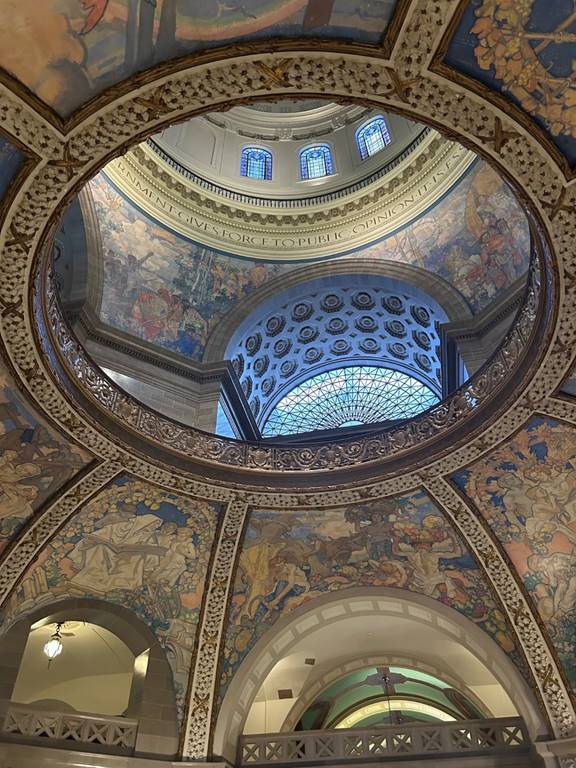
It wasn’t a long walk to the Capitol, but it was straight uphill. My legs weren’t overly enthusiastic, especially in the 90-degree heat. We ended up missing the tour by 15 minutes, but they allowed us to take a self-guided tour instead. We started in the ornate rotunda. Next we headed up to the second floor to see the famous Thomas Hart Benton murals. Glad the guard told us to stand on a mat in front of the room to activate the large wooden doors; otherwise, we’d still be standing there scratching our heads.

The series of murals that covers all four walls is titled “A Social History of The State of Missouri” and portrays the history and development of Missouri. Sitting in the oversized comfy leather chairs, the four of us tried to interpret each mural. Luckily, the tour we missed entered the room, and the docent provided a proper explanation; they also allowed us to join the remainder of the tour. We also took time to wander the Capitol museum on the first floor. Worth a visit if you are in the area.
It was now 4:30 p.m., and we were getting hungry and thirsty. We decided to head over to the Prison Brew where we had dinner reservations—more hills to climb and a 1.5-mile walk past the state prison and through a sketchy neighborhood. During dinner, everyone compared notes on their quest to find the ramp over the river and to the hotel.
Day 3: Friday, October 3rd – Jefferson City to Washington (79 miles, 679 ft of elevation)
We left the hotel at 7:00 a.m. as a group, making sure everyone found their way back to the trailhead. The sun was rising over the horizon, so we stopped at the top of the bridge for pictures. Once safely down the square bike ramp and to the trailhead, we split into our groups and headed out on our longest and hottest mileage day – 79 miles to Washington.
Nothing too notable on this section of the trail except Standing Rock, a large sandstone artifact that was left behind by millions of years of weathering, and a pair of painted grain elevators.
Lunch was at a supermarket just off the trail. I texted the group in the back on how to navigate the spur. Better to be safe than have them miss lunch.
Upon arriving at the Dutzow trailhead, we waited for the majority of the riders to catch up. It was 5+ miles on very busy roads, with three climbs to get to the hotel in Washington. On a Friday at 3:30 p.m., the streets were very busy. Hot and tired, this was the least favorite part of the trip for me. Once at the hotel, we were informed that the elevator was broken and our rooms were located on the second floor. The hotel offered to lock our bikes in the breakfast room, but not wanting to leave it out of my sight, I hauled everything up a flight of stairs. Guess hauling my bike up the embankment the day before was a precursor.
Dinner was a short walk to Smokin’ Oak Wood-Fire Pizza and Taproom, a stop at DQ, and a spirited game of UNO in the hotel lobby.
Day 4: Saturday, October 4th – Washington to St Charles (41 miles, 384 ft of elevation)
We gathered at 7:00 a.m. to ride back to the trailhead as a group. The roads were still very busy, but nothing like the night before. The sun was rising over the river, so we stopped for the obligatory sunrise picture at the top of the bridge. While we were there, we talked to a local man who comes out every morning with his cup of coffee to watch the sunrise and the peregrine falcons hunt pigeons roosting under the bridge.

The views were spectacular with the low-lying fog and the angle of the sun creating a golden hue in the fields. Mornings like this never get old.

This was the shortest mileage day, but it didn’t lack in the adventure category. Midway to St. Charles, a tree completely blocked the trail, forcing us to weave our way through the branches that were insistent on grabbing the panniers and not letting go.

Shortly after the downed tree, there was huge monarch butterfly installation on the side of a bluff. Just next to the bluff were two silos painted with sunflowers. Definitely a photo op. Today, we came across more box turtles and a 1.5 foot black snake sunning themselves on the trail.


As we approached St Charles, the busier the trail got. It was probably a combination of it being a Saturday and the more populous area. Over the previous three days, we could ride side by side, chatting as the miles flew by. Today, it was a single file.
The trail was the dustiest of all four days. As we pulled into the hotel parking lot in St. Charles, I noticed my legs were caked with dust from front to back. I saw it as a badge of honor, making it 231 miles on the historic Katy Trail.
What I’d Do Different
I was really pleased with my bike and gear choice. The 45c tires gave me a smoother ride on the bumpy trail sections. I would either remove the single pannier on the front fork or use two to distribute the weight evenly. I often take pictures while riding, but the single front pannier made balancing with one hand more difficult.
If you are more interested in a scenic ride, I’d start in Booneville instead of Windsor. If the goal is to ride the whole Katy Trail, then start farther west, even as far as Kansas City.
Cell coverage was better than in 2016, but many of us put our phones on Airplane Mode to conserve battery life. I regret leaving my battery pack at home. Be sure to grab a paper map (available at any hotel, trailhead, or bike shop) to determine the distance to the next town and the services available. The trailhead kiosk has the town’s history, mileage, and a few points of interest.
Lastly, I would not suggest staying in Washington. Personally, the 5+ miles on busy roads was not worth it. Unfortunately, the drivers I encountered were not friendly to bikers. In fact, during the four days, three drivers rolled coal on us. Totally unnecessary.
Gear List
Salsa Cutthroat with 45cm Panaracer Gravelking X1 Plus tires (same tires used for my Unbound Gravel race)
Tailfin AeroPack Cargo Rack and Ultradurable 22L panniers
Handlestash Stashquatch Handlebar Bag
Garmin Edge 1040 Plus Solar (used 56% of the battery for the entire trip)
Garmin Varia Rear Radar with taillight (for when on roads)
KOM Cycling Quick Release Light 1000
RAB Cinder Cargo bib shorts (3 days)
Peppermint Cycling bib shorts (1 day)
Smith Engage helmet (visor provided added sun protection)
Katy Trail Resources:
BikeKatyTrail.com – The bible for everything Katy Trail: lodging, points of interest, maps, restaurants, etc.
www.MOStateParks.com – The Katy Trail is designated a Missouri State Park
https://www.traillink.com/trail/katy-trail-state-park/ – TrailLink is a trail conservancy, and the site features info on trails around the country.
PBS Documentary: From Rails to Trails
Interested in the history of turning abandoned railroad corridors into trails? PBS is airing a documentary titled “From Rails to Trails.” Starting October 15, 2025, it will be available via the PBS app and at www.pbs.org/show/from-rails-to-trails, or you can watch it on your local public television station.
As initially seen on Road Bike Rider.

Super report Sheri. Plus some lovely photos. I really enjoy reading your stuff. Pam X
LikeLike
Thanks. Glad you enjoyed it.
LikeLike